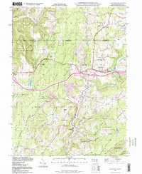
1994 Map of Grantsville
USGS Topo · Published 1999About this map
The Casselman River winds through this Maryland-Pennsylvania borderlands area, anchoring a landscape where mountain ridges and deep creek valleys define the local settlement patterns. Grantsville serves as the primary hub, situated near the National Road and the Casselman River Bridge State Park. The terrain is characterized by prominent elevations such as Negro Mtn and Meadow Mountain, with the Savage River State Forest covering much of the western and southern reaches.
Find a feature on this map
63 named features on this map. Tap any name to fly to it.
Don’t see what you’re looking for? This feature index may not catch every label — zoom into the map to look around manually.
Map Details
Editions of this 1994 Grantsville Map
This is the sole edition of this map. No revisions or reprints were ever made.
Other maps of this area

1899 · Grantsville
USGS Topo · 1:62,500

1900 · Accident
USGS Topo · 1:62,500

1904 · Grantsville
USGS Topo · 1:62,500

1921 · Meyersdale
USGS Topo · 1:62,500

1922 · Confluence
USGS Topo · 1:62,500

1931 · Confluence
USGS Topo · 1:62,500

1933 · Confluence
USGS Topo · 1:62,500

1939 · Meyersdale
USGS Topo · 1:62,500

1944 · Meyersdale
USGS Topo · 1:62,500

1946 · Grantsville
USGS Topo · 1:24,000