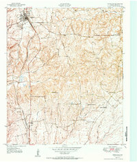
1951 Map of Grapeland
USGS Topo · Published 1951About this map
Grapeland stands as a primary railroad hub along the Missouri Pacific line in this early 1950s survey of northern Houston County. The settlement pattern is defined by a dense network of country roads connecting numerous family and community landmarks, such as Murdock Cem and Davidson Cem. To the south, the community of Latexo is anchored by the Latexo Sch and the adjacent Latexo Cem, illustrating a rural landscape where social life centered on local schools and churches.
Find a feature on this map
30 named features on this map. Tap any name to fly to it.
Don’t see what you’re looking for? This feature index may not catch every label — zoom into the map to look around manually.
Map Details
Editions of this 1951 Grapeland Map
Other maps of this area

1950 · Crockett
USGS Topo · 1:24,000

1950 · Crockett NE
USGS Topo · 1:24,000

1951 · Crockett
USGS Topo · 1:24,000

1951 · Grapeland
USGS Topo · 1:24,000

1951 · Berea
USGS Topo · 1:24,000

1951 · Crockett NE
USGS Topo · 1:24,000

1951 · Elkhart
USGS Topo · 1:62,500

1952 · Slocum
USGS Topo · 1:62,500

1953 · Palestine
USGS Topo · 1:250,000

1957 · Palestine
USGS Topo · 1:250,000