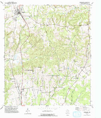
1951 Map of Grapeland
USGS Topo · Published 1993About this map
Grapeland sits at the northern edge of this Houston County landscape, where the rail line and a prominent Water Tank anchor the local economy during the mid-century. The terrain is defined by a dense network of small family cemeteries and rural congregations, reflecting the dispersed agricultural settlement patterns of East Texas. To the south, the community of Latexo is served by the Latexo Sch, while the surrounding countryside is dotted with spiritual centers such as Ephesus Ch and Union Chapel.
Find a feature on this map
35 named features on this map. Tap any name to fly to it.
Don’t see what you’re looking for? This feature index may not catch every label — zoom into the map to look around manually.
Map Details
Editions of this 1951 Grapeland Map
Other maps of this area

1950 · Crockett
USGS Topo · 1:24,000

1950 · Crockett NE
USGS Topo · 1:24,000

1951 · Crockett
USGS Topo · 1:24,000

1951 · Grapeland
USGS Topo · 1:24,000

1951 · Berea
USGS Topo · 1:24,000

1951 · Crockett NE
USGS Topo · 1:24,000

1951 · Elkhart
USGS Topo · 1:62,500

1952 · Slocum
USGS Topo · 1:62,500

1953 · Palestine
USGS Topo · 1:250,000

1957 · Palestine
USGS Topo · 1:250,000