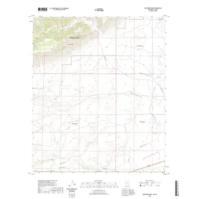
2020 Map of Grapevine Draw
USGS Topo · Published 2020About this map
Carlsbad Caverns National Park dominates the northern reaches of this landscape, where the Chihuahuan Desert meets the uplifted limestone of the Guadalupe Mountains. The terrain is defined by a series of deep incisions including West Slaughter Canyon and Midnight Canyon, while the southern lowlands are characterized by broad ephemeral drainages like Grapevine Draw and Thurman Draw. Water sources are critical landmarks in this arid environment, ranging from the School Section Water Hole to secluded points like Longview Spring and Spring Number Eleven. The road network, including Washington Ranch Rd and Mescal Draw Rd, illustrates the ranching infrastructure that exists alongside federally protected wilderness. Hikers and researchers can trace the historic Slaughter Canyon Trail as it climbs from the draws into the rugged canyon systems.
Find a feature on this map
35 named features on this map. Tap any name to fly to it.
Don’t see what you’re looking for? This feature index may not catch every label — zoom into the map to look around manually.
Map Details
Editions of this 2020 Grapevine Draw Map
This is the sole edition of this map. No revisions or reprints were ever made.
Other maps of this area

1940 · Carlsbad Caverns West
USGS Topo · 1:62,500

1943 · Carlsbad Caverns West
USGS Topo · 1:62,500

1945 · Carlsbad Caverns East
USGS Topo · 1:62,500

1947 · Carlsbad Caverns East
USGS Topo · 1:62,500

1954 · Carlsbad
USGS Topo · 1:250,000

1954 · Van Horn
USGS Topo · 1:250,000

1958 · Van Horn
USGS Topo · 1:250,000

1958 · Carlsbad
USGS Topo · 1:250,000
1973 · Independence Spring
USGS Topo · 1:24,000
1973 · South Rector Canyon
USGS Topo · 1:24,000