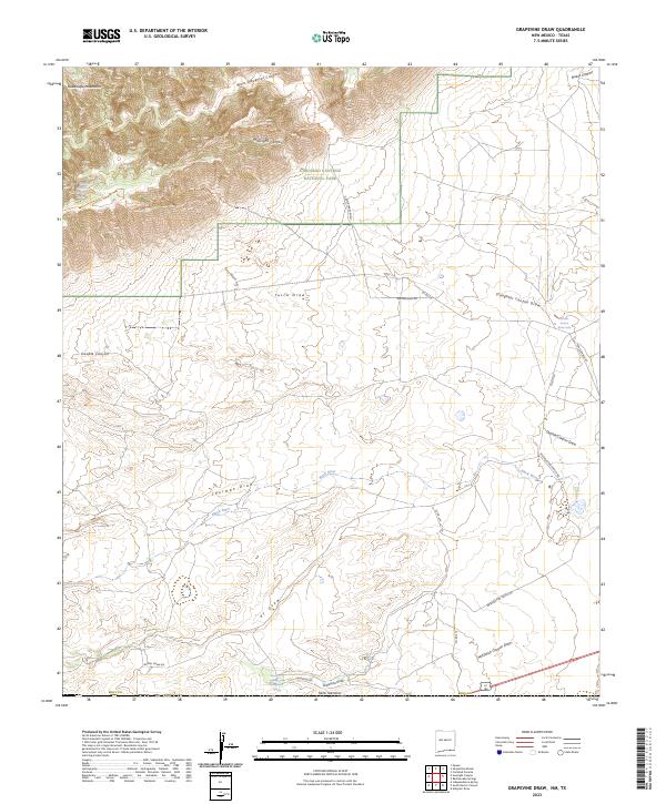
2023 Map of Grapevine Draw
USGS Topo · Published 2023About this map
Carlsbad Caverns National Park dominates the northern landscape of this survey, where the rugged Guadalupe Mountains transition into a complex system of canyons and draws. The high country is marked by deep incisions like West Slaughter Canyon and Midnight Canyon, with the Carlsbad Caverns Wilderness preserving the primitive character of the terrain.
Find a feature on this map
36 named features on this map. Tap any name to fly to it.
Don’t see what you’re looking for? This feature index may not catch every label — zoom into the map to look around manually.
Map Details
Editions of this 2023 Grapevine Draw Map
This is the sole edition of this map. No revisions or reprints were ever made.
Other maps of this area

1940 · Carlsbad Caverns West
USGS Topo · 1:62,500

1943 · Carlsbad Caverns West
USGS Topo · 1:62,500

1945 · Carlsbad Caverns East
USGS Topo · 1:62,500

1947 · Carlsbad Caverns East
USGS Topo · 1:62,500

1954 · Carlsbad
USGS Topo · 1:250,000

1954 · Van Horn
USGS Topo · 1:250,000

1958 · Van Horn
USGS Topo · 1:250,000

1958 · Carlsbad
USGS Topo · 1:250,000
1973 · Independence Spring
USGS Topo · 1:24,000
1973 · South Rector Canyon
USGS Topo · 1:24,000