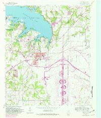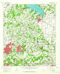
1959 Map of Grapevine
USGS Topo · Published 1964About this map
Grapevine Reservoir dominates the northern landscape of this Tarrant County survey, a major water feature surrounded by emerging mid-century communities. To the south, the massive Greater Southwest International Airport anchors the region's burgeoning aviation infrastructure, complemented by smaller local strips like Mangham Airport. The map documents a period of rapid suburban growth as the developed footprints of North Richland Hills, Hurst, and Haltom City expand toward the West Fork Trinity River.
Find a feature on this map
90 named features on this map. Tap any name to fly to it.
Don’t see what you’re looking for? This feature index may not catch every label — zoom into the map to look around manually.
Map Details
Editions of this 1959 Grapevine Map
This is the sole edition of this map. No revisions or reprints were ever made.
Historical Maps of Fort Worth Through Time
8 maps found