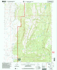
2002 Map of Grass Lakes
USGS Topo · Published 2005About this map
The East Fork Sevier River carves through the western reaches of this high-elevation landscape, defining the character of Johns Valley. The terrain rises sharply to the east into the Escalante Mountains and the high plateaus of Griffin Top and Western Top. Managed by the Escalante Ranger District of the Dixie National Forest, this area is a complex network of hydrological features and steep ridges. The namesake Grass Lakes sit nestled among the timbered heights alongside numerous named water bodies like Otter Lake and Bug Lake. The map reveals a land utilized for seasonal grazing and water management, indicated by labels such as Ranch Creek and Cougar Spring, while the primitive Pacer Lake Trail provides one of the few established routes across the timbered uplands of Section Ridge.
Find a feature on this map
31 named features on this map. Tap any name to fly to it.
Don’t see what you’re looking for? This feature index may not catch every label — zoom into the map to look around manually.
Map Details
Editions of this 2002 Grass Lakes Map
This is the sole edition of this map. No revisions or reprints were ever made.
Other maps of this area

1885 · Beaver
USGS Topo · 1:250,000

1885 · Fish Lake
USGS Topo · 1:250,000

1886 · Kanab
USGS Topo · 1:250,000

1886 · Escalante
USGS Topo · 1:250,000

1896 · Fish Lake
USGS Topo · 1:250,000

1953 · Richfield
USGS Topo · 1:250,000

1953 · Cedar City
USGS Topo · 1:250,000

1956 · Escalante
USGS Topo · 1:250,000

1956 · Salina
USGS Topo · 1:250,000

1958 · Richfield
USGS Topo · 1:250,000