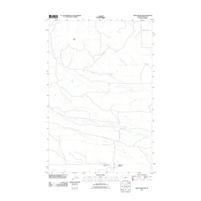
2011 Map of Grass Range NW
USGS Topo · Published 2011About this map
Bell Ranch Colony serves as a primary hub of human activity within this central Montana landscape, situated at the edge of the plains before they rise toward Black Butte. The area is defined by a dendritic network of drainages, including the meandering Brickyard Creek and South Fork Bear Creek, which navigate the subtle changes in elevation typical of this region's high prairie. The infrastructure here is sparse but functional, centered on water management and rural transit. The presence of the Ruseteun Number 2 Dam on the southern edge indicates the critical importance of water storage for local agriculture and ranching operations. Tracing the paths of Fords Creek Rd and Bowser Rd reveals the remote connectivity of this Fergus County territory in the early twenty-first century.
Find a feature on this map
9 named features on this map. Tap any name to fly to it.
Don’t see what you’re looking for? This feature index may not catch every label — zoom into the map to look around manually.
Map Details
Editions of this 2011 Grass Range NW Map
This is the sole edition of this map. No revisions or reprints were ever made.
Other maps of this area

1941 · Judith Peak
USGS Topo · 1:62,500

1944 · Judith Peak
USGS Topo · 1:62,500

1954 · Lewistown
USGS Topo · 1:250,000

1959 · Lewistown
USGS Topo · 1:250,000

1978 · Lewistown
USGS Topo · 1:100,000

1985 · Fergus
USGS Topo · 1:24,000

1985 · Roy
USGS Topo · 1:24,000
1985 · Bohemian Corners
USGS Topo · 1:24,000
1985 · Lewis Peak
USGS Topo · 1:24,000
1985 · Horsethief Coulee East
USGS Topo · 1:24,000