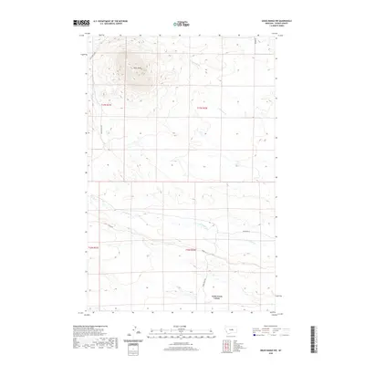
2020 Map of Grass Range NW
USGS Topo · Published 2020About this map
Black Butte rises prominently in the northwestern corner of this central Montana landscape, serving as a primary topographic landmark for the surrounding plains. The southern portion of the quadrangle is defined by the agricultural and communal footprint of the Fords Creek Colony, situated near the banks of Fords Cr. The area's hydrology is further shaped by the winding paths of Brickyard Cr and the drainage of S Fork Bear Cr to the northeast. A sparse network of rural routes, including Black Butte Rd, Sumac Rd, and Fords Creek Rd, connects the isolated farmsteads and communal holdings. This contemporary survey illustrates the persistent ranching and communal farming patterns that characterize Fergus County, where large-scale land management and natural drainage systems dictate the layout of human habitation.
Find a feature on this map
14 named features on this map. Tap any name to fly to it.
Don’t see what you’re looking for? This feature index may not catch every label — zoom into the map to look around manually.
Map Details
Editions of this 2020 Grass Range NW Map
This is the sole edition of this map. No revisions or reprints were ever made.
Other maps of this area

1941 · Judith Peak
USGS Topo · 1:62,500

1944 · Judith Peak
USGS Topo · 1:62,500

1954 · Lewistown
USGS Topo · 1:250,000

1959 · Lewistown
USGS Topo · 1:250,000

1978 · Lewistown
USGS Topo · 1:100,000

1985 · Fergus
USGS Topo · 1:24,000

1985 · Roy
USGS Topo · 1:24,000
1985 · Bohemian Corners
USGS Topo · 1:24,000
1985 · Lewis Peak
USGS Topo · 1:24,000
1985 · Horsethief Coulee East
USGS Topo · 1:24,000