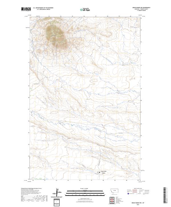
2024 Map of Grass Range NW
USGS Topo · Published 2024About this map
Black Butte rises as the dominant topographic landmark in this section of Fergus County, overlooking a landscape defined by the drainage systems of South Fork Bear Creek and Brickyard Creek. The settlement of Fords Creek Colony anchors the southeastern corner, where the Ford's Creek Colony Cem and the junction of Fords Creek Rd and Sumac Rd provide a clear view of the area's modern land use. The map illustrates a network of rural roads, including Black Butte Rd and Bowser Rd, that follow the contours of the high plains. This contemporary survey details the intersection of public land survey boundaries like t17n r22e and t16n r21e, showing how ranching and agricultural tracts are organized around the natural watercourses.
Find a feature on this map
14 named features on this map. Tap any name to fly to it.
Don’t see what you’re looking for? This feature index may not catch every label — zoom into the map to look around manually.
Map Details
Editions of this 2024 Grass Range NW Map
This is the sole edition of this map. No revisions or reprints were ever made.
Other maps of this area

1941 · Judith Peak
USGS Topo · 1:62,500

1944 · Judith Peak
USGS Topo · 1:62,500

1954 · Lewistown
USGS Topo · 1:250,000

1959 · Lewistown
USGS Topo · 1:250,000

1978 · Lewistown
USGS Topo · 1:100,000

1985 · Fergus
USGS Topo · 1:24,000

1985 · Roy
USGS Topo · 1:24,000
1985 · Bohemian Corners
USGS Topo · 1:24,000
1985 · Lewis Peak
USGS Topo · 1:24,000
1985 · Horsethief Coulee East
USGS Topo · 1:24,000