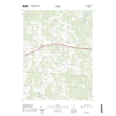
2023 Map of Gratiot
USGS Topo · Published 2023About this map
Gratiot and Brownsville sit as key points along the historic transportation corridor of the National Rd SE, a route that defined much of the early settlement pattern in this part of Licking and Muskingum counties. The landscape transitions from the higher elevations of Flint Ridge in the north toward the drainage basins of Jonathan Creek and Kent Run in the south. This area is rich with genealogical sites, including several historic burial grounds such as the Old Presbyterian Cem and Lutheran Cem. Small settlements like Wesley and Mount Perry dot the crossroads, while the presence of Porter Airport and Porter Lake near Hopewell indicates more modern land uses. The map clearly delineates the tri-county intersection of Licking, Muskingum, and Perry counties, showing how early township lines like t18n r15w continue to organize the rural property and road networks.
Find a feature on this map
93 named features on this map. Tap any name to fly to it.
Don’t see what you’re looking for? This feature index may not catch every label — zoom into the map to look around manually.
Map Details
Editions of this 2023 Gratiot Map
This is the sole edition of this map. No revisions or reprints were ever made.
Other maps of this area

1909 · Newark
USGS Topo · 1:62,500

1909 · Thornville
USGS Topo · 1:62,500

1910 · Frazeysburg
USGS Topo · 1:62,500

1910 · Zanesville
USGS Topo · 1:62,500

1947 · Columbus
USGS Topo · 1:250,000

1950 · Marion
USGS Topo · 1:250,000

1961 · Columbus
USGS Topo · 1:250,000

1961 · Hanover
USGS Topo · 1:24,000

1961 · Zanesville West
USGS Topo · 1:24,000
1961 · Fultonham
USGS Topo · 1:24,000