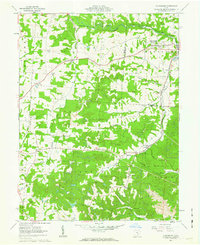
1961 Map of Fultonham
USGS Topo · Published 1963About this map
The New York Central railroad corridor serves as the industrial backbone for this section of Muskingum and Perry Counties, threading through the valleys of Jonathan Creek and Buckeye Fork. The landscape is a study in transitional land use during the early 1960s, where traditional rural life, evidenced by landmarks like Wesley Chapel and the Grange Hall, exists alongside expanding resource extraction. Significant strip mining operations are documented throughout the south and east, reshaping the hills around Redfield and East Fultonham. Genealogists will find several rural burial grounds including Bethel Cem, Mt Horeb Cem, and Zion Ch Cem. The dual identity of Fultonham (Uniontown) is preserved here, alongside smaller crossroads like Saltillo and Sego, showing a network of small Ohio villages before the consolidation of the late twentieth century.
Find a feature on this map
40 named features on this map. Tap any name to fly to it.
Don’t see what you’re looking for? This feature index may not catch every label — zoom into the map to look around manually.
Map Details
Editions of this 1961 Fultonham Map
Other maps of this area

1907 · Logan
USGS Topo · 1:62,500

1909 · Thornville
USGS Topo · 1:62,500

1909 · Logan
USGS Topo · 1:62,500

1910 · Zanesville
USGS Topo · 1:62,500

1911 · New Lexington
USGS Topo · 1:62,500

1947 · Columbus
USGS Topo · 1:250,000

1961 · Columbus
USGS Topo · 1:250,000

1961 · New Lexington
USGS Topo · 1:24,000

1961 · Deavertown
USGS Topo · 1:24,000

1961 · Zanesville West
USGS Topo · 1:24,000