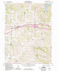
1992 Map of Gratiot
USGS Topo · Published 1995About this map
Flint Ridge dominates the northern terrain of this Central Ohio landscape, where the borders of Licking, Muskingum, and Perry Counties converge. The village of Gratiot serves as a focal point along the historic U S 40 corridor, positioned just north of the more modern Interstate 70. This map illustrates a transition from the agricultural and residential patterns of Hopewell and Mt Sterling to the industrial activity of several Strip Mines located near the eastern edge.
Find a feature on this map
36 named features on this map. Tap any name to fly to it.
Don’t see what you’re looking for? This feature index may not catch every label — zoom into the map to look around manually.
Map Details
Editions of this 1992 Gratiot Map
This is the sole edition of this map. No revisions or reprints were ever made.
Other maps of this area

1909 · Newark
USGS Topo · 1:62,500

1909 · Thornville
USGS Topo · 1:62,500

1910 · Frazeysburg
USGS Topo · 1:62,500

1910 · Zanesville
USGS Topo · 1:62,500

1947 · Columbus
USGS Topo · 1:250,000

1950 · Marion
USGS Topo · 1:250,000

1961 · Columbus
USGS Topo · 1:250,000

1961 · Hanover
USGS Topo · 1:24,000

1961 · Zanesville West
USGS Topo · 1:24,000
1961 · Fultonham
USGS Topo · 1:24,000