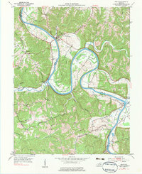
1953 Map of Gratz
USGS Topo · Published 1983About this map
The Kentucky River carves a dramatic series of horseshoe bends through the limestone hills of central Kentucky, defining the winding boundary between Henry and Owen Counties. The settlement of Gratz sits at a strategic crossing near the mouth of Londerback Br, while the river's navigation is maintained through civil engineering at Lock No 2 and further south at Lock No 3 near Gest. These locks were vital for moving goods through the interior before modern overland transport fully eclipsed river traffic.
Find a feature on this map
42 named features on this map. Tap any name to fly to it.
Don’t see what you’re looking for? This feature index may not catch every label — zoom into the map to look around manually.
Map Details
Editions of this 1953 Gratz Map
3 editions found
Other maps of this area

1906 · Lockport
USGS Topo · 1:48,000

1908 · Lockport
USGS Topo · 1:62,500

1928 · New Castle
USGS Topo · 1:48,000

1932 · New Castle
USGS Topo · 1:62,500

1950 · New Liberty
USGS Topo · 1:24,000

1950 · Owenton
USGS Topo · 1:24,000

1952 · Worthville
USGS Topo · 1:24,000

1953 · Monterey
USGS Topo · 1:24,000

1953 · Gratz
USGS Topo · 1:24,000

1953 · Polsgrove
USGS Topo · 1:24,000