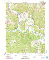
1953 Map of Gratz
USGS Topo · Published 1987About this map
The Kentucky River carves a winding path through the borderlands of Henry and Owen Counties, defining the local geography with its dramatic horseshoe bends. In this 1953 survey, the river remains the central artery for small communities like Gratz, Lockport, and Monterey. The presence of Lock No 2 and Lock No 3 highlights the historical importance of river navigation and water control in the region.
Find a feature on this map
46 named features on this map. Tap any name to fly to it.
Don’t see what you’re looking for? This feature index may not catch every label — zoom into the map to look around manually.
Map Details
Editions of this 1953 Gratz Map
3 editions found
Other maps of this area

1906 · Lockport
USGS Topo · 1:48,000

1908 · Lockport
USGS Topo · 1:62,500

1928 · New Castle
USGS Topo · 1:48,000

1932 · New Castle
USGS Topo · 1:62,500

1950 · New Liberty
USGS Topo · 1:24,000

1950 · Owenton
USGS Topo · 1:24,000

1952 · Worthville
USGS Topo · 1:24,000

1953 · Monterey
USGS Topo · 1:24,000

1953 · Gratz
USGS Topo · 1:24,000

1953 · Polsgrove
USGS Topo · 1:24,000