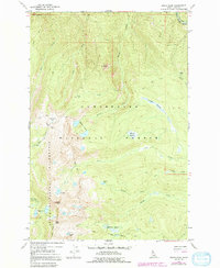
1966 Map of Grave Peak
USGS Topo · Published 1992About this map
Grave Peak serves as the focal point of this high-elevation wilderness survey, marking the dramatic topography within the Selway-Bitterroot Wilderness and Clearwater National Forest. The landscape is defined by its numerous alpine water bodies, including Walton Lakes, Colt Lake, Wind Lakes, and Grouse Lake. This 1966 fieldwork, later revised in the early 1980s, documents a region largely inaccessible except by foot or hoof, as evidenced by the network of Pack Trails and the Tom Beal Pack Trail threading through the peaks. High passes such as Friday Pass and Savage Pass connect the drainage basins of Walton Creek, Colt Creek, and Swamp Creek. The map provides a detailed look at distinct high-mountain ecosystems, from the prominent Goat Roost and Jay Point to the expansive Kooskooskia Meadows and Sheakfoot Meadows, which offer breaks in the dense forest cover of northern Idaho.
Find a feature on this map
30 named features on this map. Tap any name to fly to it.
Don’t see what you’re looking for? This feature index may not catch every label — zoom into the map to look around manually.
Map Details
Editions of this 1966 Grave Peak Map
3 editions found
Other maps of this area

1911 · Lolo
USGS Topo · 1:250,000

1913 · Lolo
USGS Topo · 1:250,000

1956 · Hamilton
USGS Topo · 1:250,000

1959 · Hamilton
USGS Topo · 1:250,000

1960 · Hamilton
USGS Topo · 1:250,000

1964 · Hamilton
USGS Topo · 1:250,000

1964 · Rocky Point
USGS Topo · 1:24,000

1964 · Roundtop
USGS Topo · 1:24,000

1966 · Grave Peak
USGS Topo · 1:24,000
1966 · Hungry Rock
USGS Topo · 1:24,000