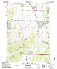
1992 Map of Gray Butte
USGS Topo · Published 1997About this map
Gray Butte rises as the dominant landmark in this central Oregon landscape, where the high desert terrain of the Crooked River National Grassland meets the irrigation networks of the south. The map documents a sparsely populated ranching and utility corridor, evidenced by the Madras Compressor Sta and a prominent north-south Pipeline. Genealogists and local historians can locate the Gray Butte Cem and the Lone Pine Sch, while family-named water sources like Omar Cyrus Spring, Lower Cyrus Spring, and Rodman Spring point to the early homesteading history of the area.
Find a feature on this map
44 named features on this map. Tap any name to fly to it.
Don’t see what you’re looking for? This feature index may not catch every label — zoom into the map to look around manually.
Map Details
Editions of this 1992 Gray Butte Map
This is the sole edition of this map. No revisions or reprints were ever made.
Other maps of this area

1926 · Bend
USGS Topo · 1:125,000

1928 · Madras
USGS Topo · 1:125,000

1929 · Bend
USGS Topo · 1:125,000

1931 · Madras
USGS Topo · 1:125,000

1955 · Bend
USGS Topo · 1:250,000

1957 · Bend
USGS Topo · 1:250,000

1958 · Bend
USGS Topo · 1:250,000

1961 · Redmond
USGS Topo · 1:24,000

1962 · Opal City
USGS Topo · 1:24,000

1962 · Oneil
USGS Topo · 1:24,000