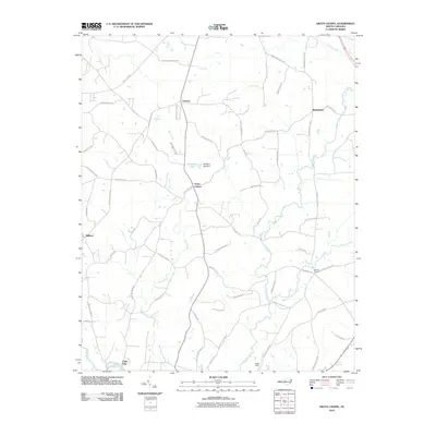
2010 Map of Grays Chapel
USGS Topo · Published 2010About this map
Grays Chapel serves as a central point in this part of Randolph County, where the landscape is defined by the winding paths of Sandy Creek and Bush Creek. The area shows a distributed rural settlement pattern typical of the North Carolina Piedmont, with small communities like Linberry, Melanchton, and Whites Chapel linked by a dense network of country roads. Many of these thoroughfares, such as Providence Church Rd and Randolph Church Rd, hint at the ecclesiastical and community foundations of the local geography.
Find a feature on this map
58 named features on this map. Tap any name to fly to it.
Don’t see what you’re looking for? This feature index may not catch every label — zoom into the map to look around manually.
Map Details
Editions of this 2010 Grays Chapel Map
This is the sole edition of this map. No revisions or reprints were ever made.
Other maps of this area

1953 · Raleigh
USGS Topo · 1:250,000

1954 · Raleigh
USGS Topo · 1:250,000

1957 · Asheboro
USGS Topo · 1:62,500

1968 · Ramseur
USGS Topo · 1:24,000

1968 · Coleridge
USGS Topo · 1:24,000

1970 · Kimesville
USGS Topo · 1:24,000
1970 · Pleasant Garden
USGS Topo · 1:24,000
1970 · Climax
USGS Topo · 1:24,000

1970 · Randleman
USGS Topo · 1:24,000

1970 · Asheboro
USGS Topo · 1:24,000