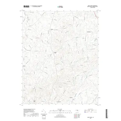
2019 Map of Grays Chapel
USGS Topo · Published 2019About this map
The Deep River corridor defines the southern landscape of this Randolph County region, where the industrial and residential centers of Ramseur, Franklinville, and Cedar Falls are situated. This area reflects a long-standing Piedmont settlement pattern where community life is tethered to the river's path. Moving north, the terrain transitions into a web of rural communities and crossroads, including Grays Chapel, Linberry, and Melanchton. The map documents a dense network of local routes such as Providence Church Rd and Sandy Creek Church Rd, which link historical family farms and local parishes. Notable landmarks like Yorks Field and the waters of Lineberry Lake and Sandy Creek illustrate the mixture of agricultural land and small-town development that characterizes this part of North Carolina.
Find a feature on this map
100 named features on this map. Tap any name to fly to it.
Don’t see what you’re looking for? This feature index may not catch every label — zoom into the map to look around manually.
Map Details
Editions of this 2019 Grays Chapel Map
This is the sole edition of this map. No revisions or reprints were ever made.
Other maps of this area

1953 · Raleigh
USGS Topo · 1:250,000

1954 · Raleigh
USGS Topo · 1:250,000

1957 · Asheboro
USGS Topo · 1:62,500

1968 · Ramseur
USGS Topo · 1:24,000

1968 · Coleridge
USGS Topo · 1:24,000

1970 · Kimesville
USGS Topo · 1:24,000
1970 · Pleasant Garden
USGS Topo · 1:24,000
1970 · Climax
USGS Topo · 1:24,000

1970 · Randleman
USGS Topo · 1:24,000

1970 · Asheboro
USGS Topo · 1:24,000