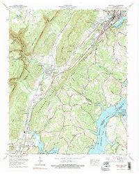
1972 Map of Graysville
USGS Topo · Published 1974About this map
The Cumberland Escarpment dominates the western landscape of this Rhea County region, where the steep terrain gives way to the industrial and agricultural valley. Graysville and Dayton serve as the primary hubs, situated along the Southern Railway corridor that facilitated local movement and commerce in the early 1970s. The map reveals a complex network of family and community landmarks, from the College Hill Sch and Spivey Sch to numerous rural cemeteries like Abel Cem and Miller-Nelson Cem, which anchor the lineage of local hollows.
Find a feature on this map
94 named features on this map. Tap any name to fly to it.
Don’t see what you’re looking for? This feature index may not catch every label — zoom into the map to look around manually.
Map Details
Editions of this 1972 Graysville Map
4 editions found
Other maps of this area

1886 · Cleveland
USGS Topo · 1:125,000

1887 · Kingston
USGS Topo · 1:125,000

1888 · Chattanooga
USGS Topo · 1:125,000

1891 · Kingston
USGS Topo · 1:125,000

1892 · Pikeville
USGS Topo · 1:125,000

1892 · Cleveland
USGS Topo · 1:125,000

1893 · Chattanooga
USGS Topo · 1:125,000

1893 · Kingston
USGS Topo · 1:125,000

1895 · Cleveland
USGS Topo · 1:125,000

1895 · Pikeville
USGS Topo · 1:125,000