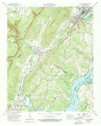
1972 Map of Graysville
USGS Topo · Published 1974About this map
The Cumberland Escarpment dominates the western horizon of this survey, where the rugged descent from the plateau meets the developing valley floor. In the early 1970s, the corridor along U.S. Highway 27 served as a primary artery connecting established settlements like Graysville and Coulterville with the growing industrial and educational footprint of Dayton. To the east, the landscape transitions into the watery expanse of Chickamauga Lake, created by the impoundment of the Tennessee River. This shoreline is marked by the Hiwassee Wildlife Refuge and the Blythe Ferry Goose Management Area near the confluence of the Hiwassee River. Numerous small family and community burial grounds, such as Abel Cem and Fairview Cem, are preserved among the ridges, documenting the deep-rooted genealogy of the region before modern suburban expansion began to alter the rural character of Rhea and Hamilton Counties.
Find a feature on this map
94 named features on this map. Tap any name to fly to it.
Don’t see what you’re looking for? This feature index may not catch every label — zoom into the map to look around manually.
Map Details
Editions of this 1972 Graysville Map
4 editions found
Other maps of this area

1886 · Cleveland
USGS Topo · 1:125,000

1887 · Kingston
USGS Topo · 1:125,000

1888 · Chattanooga
USGS Topo · 1:125,000

1891 · Kingston
USGS Topo · 1:125,000

1892 · Pikeville
USGS Topo · 1:125,000

1892 · Cleveland
USGS Topo · 1:125,000

1893 · Chattanooga
USGS Topo · 1:125,000

1893 · Kingston
USGS Topo · 1:125,000

1895 · Cleveland
USGS Topo · 1:125,000

1895 · Pikeville
USGS Topo · 1:125,000