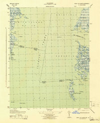
1943 Map of Great Fox Island
USGS Topo · Published 1943About this map
Tangier Sound and the intricate tidal wetlands of the Chesapeake Bay define this mid-century maritime landscape. The border between Maryland and Virginia bisects the open waters and marshy outcroppings, marking the territorial division through the Fox Islands and near Horse Hammock. This 1942 field study, published by the War Department, highlights the critical navigation aids of the era, including the James Island Lt and Somers Cove Lt, which guided watercraft through the Cedar Straits and the mouth of the Little Annemessex River.
Find a feature on this map
56 named features on this map. Tap any name to fly to it.
Don’t see what you’re looking for? This feature index may not catch every label — zoom into the map to look around manually.
Map Details
Editions of this 1943 Great Fox Island Map
This is the sole edition of this map. No revisions or reprints were ever made.
Other maps of this area

1898 · St. Marys
USGS Topo · 1:125,000

1903 · Crisfield
USGS Topo · 1:62,500

1903 · Bloodsworth Island
USGS Topo · 1:62,500

1903 · Deal Island
USGS Topo · 1:62,500

1906 · St. Marys
USGS Topo · 1:125,000

1917 · Ewell
USGS Topo · 1:62,500

1920 · Crisfield
USGS Topo · 1:62,500

1942 · Chesconessex
USGS Topo · 1:31,680

1942 · Terrapin Sand Point
USGS Topo · 1:24,000

1942 · Kedges Straits
USGS Topo · 1:24,000