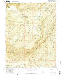
1952 Map of Greek Store
USGS Topo · Published 1975About this map
Placer Co Grove Sierra Redwoods and the deep drainage of the Middle Fork American River define this mid-century landscape in the High Sierra. This region, primarily within the Tahoe National Forest, reveals the remnants of a prolific mining era, evidenced by the high density of named claims. Clusters of activity are visible near Star Town (Site), where the Star Town Mine and Root Hog Mine once operated, and along the steep banks of Duncan Canyon.
Find a feature on this map
91 named features on this map. Tap any name to fly to it.
Don’t see what you’re looking for? This feature index may not catch every label — zoom into the map to look around manually.
Map Details
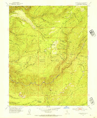
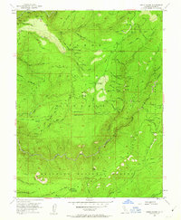
Editions of this 1952 Greek Store Map
4 editions found

Other maps of this area

1889 · Pyramid Peak
USGS Topo · 1:125,000

1891 · Colfax
USGS Topo · 1:125,000

1891 · Truckee
USGS Topo · 1:125,000

1891 · Placerville
USGS Topo · 1:125,000

1891 · Pyramid Peak
USGS Topo · 1:125,000

1892 · Placerville
USGS Topo · 1:125,000

1892 · Colfax
USGS Topo · 1:125,000

1893 · Placerville
USGS Topo · 1:125,000

1893 · Truckee
USGS Topo · 1:125,000

1894 · Colfax
USGS Topo · 1:125,000