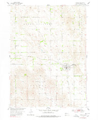
1954 Map of Greeley
USGS Topo · Published 1978About this map
Greeley (Greeley Center) stands as the central hub of this Nebraska landscape, characterized by the grid of the Chicago Burlington and Quincy railroad. The township organization is clearly visible through the numerous rural education sites, including Boston Valley Sch, Star Sch, and Reed Sch, which provided local focal points for the surrounding agricultural community. The terrain transitions from the lowlands of Freeman Valley to the higher elevations of Mount Pleasant, with drainage provided by Spring Creek and the West Branch Boston Spring Creek. An Old Railroad Grade north of the main settlement suggests an evolving transportation network. For genealogists, the map identifies specific burial grounds such as Sacred Heart Cem and Swedish Cem, offering precise locations for historical research in the heart of the Great Plains.
Find a feature on this map
19 named features on this map. Tap any name to fly to it.
Don’t see what you’re looking for? This feature index may not catch every label — zoom into the map to look around manually.
Map Details
Editions of this 1954 Greeley Map
Other maps of this area

1899 · Loup
USGS Topo · 1:125,000

1899 · St. Paul
USGS Topo · 1:125,000

1953 · Scotia NE
USGS Topo · 1:24,000

1953 · Scotia
USGS Topo · 1:24,000

1954 · Horace
USGS Topo · 1:24,000

1954 · Greeley NE
USGS Topo · 1:24,000

1954 · Greeley
USGS Topo · 1:24,000

1954 · Greeley NW
USGS Topo · 1:24,000

1954 · Spalding SW
USGS Topo · 1:24,000

1954 · Wolbach
USGS Topo · 1:24,000