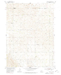
1954 Map of Greeley NW
USGS Topo · Published 1977About this map
Homestead and Parnell townships define the rural character of this central Nebraska landscape during the mid-1950s. The map captures a high-plains community organized around a grid of section lines and township boundaries, where local life centered on small landmarks like Amity Sch, Fairview Sch, and Fairdale Sch. These schools, spaced for accessibility in an era of local rural education, along with the Amity Cem, provide significant markers for genealogical research in this sparsely settled region.
Find a feature on this map
11 named features on this map. Tap any name to fly to it.
Don’t see what you’re looking for? This feature index may not catch every label — zoom into the map to look around manually.
Map Details
Editions of this 1954 Greeley NW Map
3 editions found
Other maps of this area

1954 · Ord SE
USGS Topo · 1:24,000

1954 · Gables SE
USGS Topo · 1:24,000

1954 · Ord NE
USGS Topo · 1:24,000

1954 · Horace
USGS Topo · 1:24,000

1954 · Greeley NE
USGS Topo · 1:24,000

1954 · Greeley
USGS Topo · 1:24,000

1954 · Greeley NW
USGS Topo · 1:24,000

1954 · Bartlett SE
USGS Topo · 1:24,000

1954 · Ericson
USGS Topo · 1:24,000

1955 · Broken Bow
USGS Topo · 1:250,000