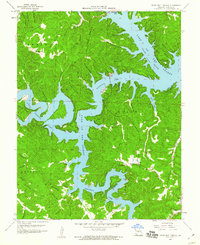
1959 Map of Green Bay Terrace
USGS Topo · Published 1960About this map
Niangua Arm Lake of the Ozarks and the Little Niangua Arm dominate this late-1950s landscape, illustrating the jagged, branching shoreline that characterizes the Camden County lake region. The map captures the community of Hurricane Deck and the resort-focused layout of Green Bay Terrace during a period of significant recreational growth. Inland from the water, the terrain is defined by complex ridge and hollow systems, including Sinkhole Ridge and Dunkin Ridge, which suggest the area's karst topography.
Find a feature on this map
58 named features on this map. Tap any name to fly to it.
Don’t see what you’re looking for? This feature index may not catch every label — zoom into the map to look around manually.
Map Details
Editions of this 1959 Green Bay Terrace Map
3 editions found
Other maps of this area

1888 · Versailles
USGS Topo · 1:125,000

1893 · Versailles
USGS Topo · 1:125,000

1932 · Versailles No 4
USGS Topo · 1:48,000

1933 · Stoutland
USGS Topo · 1:62,500

1934 · Macks Creek
USGS Topo · 1:48,000

1934 · Camdenton
USGS Topo · 1:24,000

1934 · Purvis
USGS Topo · 1:24,000

1934 · Irontown Ferry
USGS Topo · 1:24,000

1934 · Lake Ozark
USGS Topo · 1:24,000

1934 · Green Bay Terrace
USGS Topo · 1:24,000