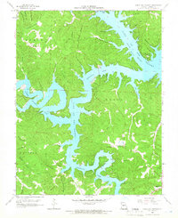
1959 Map of Green Bay Terrace
USGS Topo · Published 1966About this map
Lake of the Ozarks dominates this landscape, its intricate shoreline forming the deep Niangua Arm and Little Niangua Arm. The map reveals a mid-century period of transition as the lakeside community of Green Bay Terrace begins to take shape amidst long-established Ozark landmarks. Historical researchers can identify several rural anchors such as Mt Taber Ch, the New Home Ch, and the secluded Farmer Cem. The terrain is defined by a dense network of ridges and hollows, including the curiously named Deadman Ridge and Standing Rock Hollow. Recreation and tourism are evident through the presence of Bridal Cave and a Lookout Tower near the water, while the interior remains divided into older land partitions such as Adair, Russell, and Osage.
Find a feature on this map
52 named features on this map. Tap any name to fly to it.
Don’t see what you’re looking for? This feature index may not catch every label — zoom into the map to look around manually.
Map Details
Editions of this 1959 Green Bay Terrace Map
3 editions found
Other maps of this area

1888 · Versailles
USGS Topo · 1:125,000

1893 · Versailles
USGS Topo · 1:125,000

1932 · Versailles No 4
USGS Topo · 1:48,000

1933 · Stoutland
USGS Topo · 1:62,500

1934 · Macks Creek
USGS Topo · 1:48,000

1934 · Camdenton
USGS Topo · 1:24,000

1934 · Purvis
USGS Topo · 1:24,000

1934 · Irontown Ferry
USGS Topo · 1:24,000

1934 · Lake Ozark
USGS Topo · 1:24,000

1934 · Green Bay Terrace
USGS Topo · 1:24,000