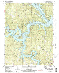
1983 Map of Green Bay Terrace
USGS Topo · Published 1983About this map
Lake of the Ozarks dominates this central Missouri landscape, with its intricate fingers and coves defining the development around Green Bay Terrace and Camdenton. The map documents a mature recreational and residential landscape in the early 1980s, where the winding Niangua Arm meets the convergence of the Niangua River and Little Niangua River. This survey provides a record of human and geological convergence, featuring the prominent Hurricane Deck plateau and the famous Bridal Cave near Bull Run Bluff. Local history is preserved through labels for the Farmer Cem and Tick Ridge Cem, alongside community landmarks like Windermere Church Camp and the Camdenton Towersite State Wildlife Management Area. The network of hills and hollows, such as Wolfpen Hollow and Arnhold Ridge, illustrates the complex topography that predates the reservoir's creation, while modern infrastructure like the Radio Tower and Camdenton Medical Center show the area's growth as a regional hub.
Find a feature on this map
81 named features on this map. Tap any name to fly to it.
Don’t see what you’re looking for? This feature index may not catch every label — zoom into the map to look around manually.
Map Details
Editions of this 1983 Green Bay Terrace Map
2 editions found
Other maps of this area

1888 · Versailles
USGS Topo · 1:125,000

1893 · Versailles
USGS Topo · 1:125,000

1932 · Versailles No 4
USGS Topo · 1:48,000

1933 · Stoutland
USGS Topo · 1:62,500

1934 · Macks Creek
USGS Topo · 1:48,000

1934 · Camdenton
USGS Topo · 1:24,000

1934 · Purvis
USGS Topo · 1:24,000

1934 · Irontown Ferry
USGS Topo · 1:24,000

1934 · Lake Ozark
USGS Topo · 1:24,000

1934 · Green Bay Terrace
USGS Topo · 1:24,000