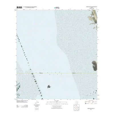
2012 Map of Green Island
USGS Topo · Published 2012About this map
Green Island stands as a prominent landmark within the coastal waters of South Texas, surrounded by the shifting shoals and shallow basins of the Laguna Madre. This 2012 survey by the U.S. Geological Survey provides a precise view of the estuarine environment just north of the Rio Grande Valley. The map captures the isolation of the shoreline and the delicate coastal geography, including Deer Island further to the east. These landforms are critical markers for maritime navigation and environmental study in an area defined by minimal terrestrial features and extensive submerged lands.
Find a feature on this map
2 named features on this map. Tap any name to fly to it.
Don’t see what you’re looking for? This feature index may not catch every label — zoom into the map to look around manually.
Map Details
Editions of this 2012 Green Island Map
This is the sole edition of this map. No revisions or reprints were ever made.
Other maps of this area

1929 · Buena Vista
USGS Topo · 1:24,000

1930 · La Leona
USGS Topo · 1:24,000

1930 · Padre Island No. 2
USGS Topo · 1:24,000

1935 · Padre Island NO. 2
USGS Topo · 1:31,680

1935 · Buena Vista
USGS Topo · 1:31,680

1936 · La Leona
USGS Topo · 1:31,680

1952 · Green Island
USGS Topo · 1:24,000
1952 · North Of Port Isabel NW
USGS Topo · 1:24,000

1952 · South of Potrero Lopeno SE
USGS Topo · 1:24,000

1952 · Hawk Island
USGS Topo · 1:24,000