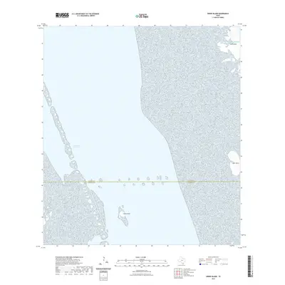
2022 Map of Green Island
USGS Topo · Published 2022About this map
Green Island stands as a central landform within the Laguna Madre coastal waters, where the maritime boundary between Willacy Co and Cameron Co is delineated. This 2022 survey details a portion of the Texas coastline defined by the shifting barrier of Padre Island to the east and the busy passage of the Intracoastal Waterway to the west. The landscape is characterized by small, scattered landmasses such as Deer Island set against the expanse of the Gulf of Mexico. The map documents the modern hydrography of this shallow lagoon system, emphasizing the navigational corridors and natural shoals that shape the South Texas shoreline during the early 21st century.
Find a feature on this map
6 named features on this map. Tap any name to fly to it.
Don’t see what you’re looking for? This feature index may not catch every label — zoom into the map to look around manually.
Map Details
Editions of this 2022 Green Island Map
This is the sole edition of this map. No revisions or reprints were ever made.
Other maps of this area

1929 · Buena Vista
USGS Topo · 1:24,000

1930 · La Leona
USGS Topo · 1:24,000

1930 · Padre Island No. 2
USGS Topo · 1:24,000

1935 · Padre Island NO. 2
USGS Topo · 1:31,680

1935 · Buena Vista
USGS Topo · 1:31,680

1936 · La Leona
USGS Topo · 1:31,680

1952 · Green Island
USGS Topo · 1:24,000
1952 · North Of Port Isabel NW
USGS Topo · 1:24,000

1952 · South of Potrero Lopeno SE
USGS Topo · 1:24,000

1952 · Hawk Island
USGS Topo · 1:24,000