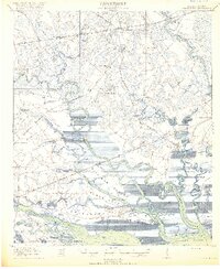
1918 Map of Green Pond
USGS Topo · Published 1918About this map
The Combahee River and Ashepoo River snake through a dense landscape of South Carolina lowcountry wetlands, defining the tidal environment of Colleton and Beaufort counties. In 1918, this area was a critical corridor for the Atlantic Coast Line and Seaboard Air Line railroads, which facilitated the movement of goods through settlements like Whitehall and Green Pond. The map reveals a deeply established social fabric evidenced by numerous rural houses of worship, including St Marys Church, Bosom Bottom Church, and First African Church. The transition from water to land is marked by complex islands such as the Williman Islands and Chisholm Islands, separated by thoroughfares like Schooner Channel. Along the riverbanks, remnants of earlier eras appear at Old Fort and the Combahee Ferry crossing, while the local economy is anchored by sites like Waters Store and the rail siding at Ashepoo.
Find a feature on this map
65 named features on this map. Tap any name to fly to it.
Don’t see what you’re looking for? This feature index may not catch every label — zoom into the map to look around manually.
Map Details
Editions of this 1918 Green Pond Map
4 editions found
Other maps of this area

1918 · Walterboro
USGS Topo · 1:62,500

1918 · Green Pond
USGS Topo · 1:62,500

1918 · Yemassee
USGS Topo · 1:62,500

1918 · Cottageville
USGS Topo · 1:62,500

1919 · Edisto Island
USGS Topo · 1:62,500

1919 · Cummings
USGS Topo · 1:62,500

1920 · Okatie
USGS Topo · 1:62,500

1920 · St. Helena Sound
USGS Topo · 1:62,500

1942 · Okatie
USGS Topo · 1:62,500

1943 · Cottageville
USGS Topo · 1:62,500