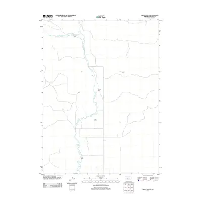
2011 Map of Green Ranch
USGS Topo · Published 2011About this map
Birdwood Creek and its tributary, West Birdwood Creek, anchor this landscape in Lincoln County, Nebraska, where the terrain is defined by large-scale ranching and a sparse network of section roads. The map illustrates a contemporary pattern of land use where named homesteads serve as the primary landmarks in the Sandhills region. These include the central Green Ranch, Richardson Ranch to the north, and the Dikeman Ranch and Fleecs Ranch further south. The transportation infrastructure is primarily functional, consisting of unpaved routes such as N Birdwood Rd, N Sand Rd, and Fleecs Rd. This survey captures the spatial relationship between water sources and established ranching operations, documenting the enduring footprint of family names on the Nebraska plains.
Find a feature on this map
13 named features on this map. Tap any name to fly to it.
Don’t see what you’re looking for? This feature index may not catch every label — zoom into the map to look around manually.
Map Details
Editions of this 2011 Green Ranch Map
This is the sole edition of this map. No revisions or reprints were ever made.
Other maps of this area

1898 · Paxton
USGS Topo · 1:125,000

1899 · North Platte
USGS Topo · 1:125,000

1901 · Paxton
USGS Topo · 1:125,000

1902 · North Platte
USGS Topo · 1:125,000

1954 · North Platte
USGS Topo · 1:250,000

1956 · North Platte
USGS Topo · 1:250,000

1957 · North Platte
USGS Topo · 1:250,000

1967 · North Platte
USGS Topo · 1:250,000
1970 · Hershey East
USGS Topo · 1:24,000
1971 · Hershey West
USGS Topo · 1:24,000