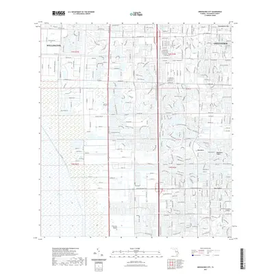
2021 Map of Greenacres City
USGS Topo · Published 2021About this map
The Everglades define the western margin of this survey, meeting the structured residential expansion of Palm Beach County. The landscape is a study in modern water management and suburban planning, centered around the municipalities of Wellington and Greenacres City. Extensive drainage and irrigation infrastructure, such as the 40 Canal, are visible alongside major thoroughfares like Lantana Rd and Hypoluxo Rd. These roads connect established neighborhoods like Aberdeen and Rainbow Lakes to local landmarks, including the Saint Vincent de Paul Regional Seminary. The map also captures significant commemorative spaces, notably the South Florida National Cem and the Eternal Light Memorial Gardens, providing essential geographic context for modern family history and local land-use researchers.
Find a feature on this map
22 named features on this map. Tap any name to fly to it.
Don’t see what you’re looking for? This feature index may not catch every label — zoom into the map to look around manually.
Map Details
Editions of this 2021 Greenacres City Map
This is the sole edition of this map. No revisions or reprints were ever made.
Other maps of this area

1945 · Greenacres City
USGS Topo · 1:24,000

1945 · Lake Worth
USGS Topo · 1:24,000

1946 · Palm Beach Farms
USGS Topo · 1:24,000

1946 · Palm Beach
USGS Topo · 1:24,000

1947 · Delmar Farms
USGS Topo · 1:24,000

1949 · Lake Worth
USGS Topo · 1:24,000

1949 · Palm Beach Farms
USGS Topo · 1:24,000

1949 · Delmar Farms
USGS Topo · 1:24,000

1950 · Delray Beach
USGS Topo · 1:24,000

1950 · Greenacres City
USGS Topo · 1:24,000