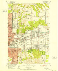
1949 Map of Greenacres
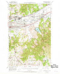
USGS Topo · Published 1970About this map
The Naval Supply Depot and the neighboring Aluminum Rolling Mill dominate the industrial landscape of the Spokane River valley in the years following World War II. This 1949 survey illustrates a region in transition, where established agricultural communities like Otis Orchards and Greenacres meet growing suburban and industrial infrastructure. The valley floor is crisscrossed by major rail lines, including the Great Northern and the Milwaukee Road, which served both the heavy industry at Trentwood and the small settlements dotting the riverbank.
Find a feature on this map
77 named features on this map. Tap any name to fly to it.
Don’t see what you’re looking for? This feature index may not catch every label — zoom into the map to look around manually.
Map Details
Editions of this 1949 Greenacres Map
3 editions found

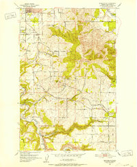
Other maps of this area

1901 · Spokane
USGS Topo · 1:125,000

1903 · Oakesdale
USGS Topo · 1:125,000

1903 · Rathdrum
USGS Topo · 1:125,000

1905 · Oakesdale
USGS Topo · 1:125,000

1943 · Mt Spokane
USGS Topo · 1:62,500

1949 · Deer Park
USGS Topo · 1:62,500

1949 · Greenacres
USGS Topo · 1:62,500
1950 · Spokane NE
USGS Topo · 1:24,000
1950 · Spokane SE
USGS Topo · 1:24,000

1950 · Mt Spokane
USGS Topo · 1:62,500