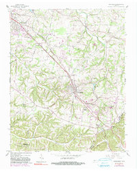
1961 Map of Greenbrier
USGS Topo · Published 1990About this map
The Louisville and Nashville railroad corridor anchors this mid-century portrait of Robertson and Davidson Counties, connecting the prominent settlements of Springfield, Greenbrier, and Ridgetop. This upland region is defined by a dense network of country roads like Betts Road and Worsham Springs Road, which serve a landscape dotted with rural institutions. Genealogists will find numerous family burial grounds including Savage Cem, Bloodworth Cem, and Baggett Cem, alongside community landmarks such as Wartrace Ch and the Oakland-Bethlehem Sch. South of Hygeia Springs, the terrain becomes more dissected as it falls toward Huffman Dividing Ridge and the headwaters of Sycamore Creek. The map documents a transition from traditional rural patterns to the inclusion of modern amenities like the Drive-in Theater near Courtland.
Find a feature on this map
69 named features on this map. Tap any name to fly to it.
Don’t see what you’re looking for? This feature index may not catch every label — zoom into the map to look around manually.
Map Details
Editions of this 1961 Greenbrier Map
3 editions found
Other maps of this area

1903 · Nashville
USGS Topo · 1:125,000

1931 · Ridgetop
USGS Topo · 1:62,500

1935 · Ridgetop
USGS Topo · 1:62,500

1942 · Gallatin
USGS Topo · 1:100,000

1952 · Goodlettsville
USGS Topo · 1:24,000

1952 · Springfield North
USGS Topo · 1:24,000

1952 · Youngville
USGS Topo · 1:24,000

1953 · Orlinda
USGS Topo · 1:24,000
1954 · White House
USGS Topo · 1:24,000

1955 · Whites Creek
USGS Topo · 1:24,000