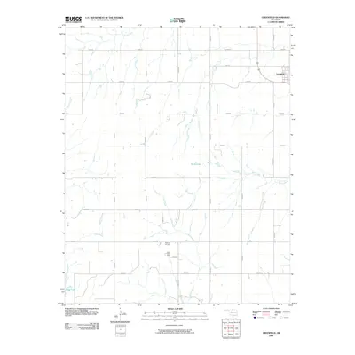
2009 Map of Greenfield
USGS Topo · Published 2009About this map
Greenfield sits at the intersection of a vast agricultural grid in Blaine County, serving as the primary hub in this prairie landscape. The area is defined by its seasonal drainage patterns, with Horse Creek and Lariat Creek carving narrow paths through the fields. In the southern portion of the quadrangle, American Horse Lake and Spring Lake provide significant water landmarks in an otherwise dry terrain. Genealogy researchers will find the Richland Cemetery located centrally, while the nearby Lariat Creek Camp indicates the area's use for organized recreation and community gathering. The map illustrates a meticulously planned road system, with numbered routes like e0890 RD and n2560 RD forming the backbone of the rural infrastructure during this era of Oklahoma's development.
Find a feature on this map
27 named features on this map. Tap any name to fly to it.
Don’t see what you’re looking for? This feature index may not catch every label — zoom into the map to look around manually.
Map Details
Editions of this 2009 Greenfield Map
This is the sole edition of this map. No revisions or reprints were ever made.
Other maps of this area

1942 · Geary
USGS Topo · 1:62,500

1955 · Clinton
USGS Topo · 1:250,000

1957 · Clinton
USGS Topo · 1:250,000

1964 · Oakwood
USGS Topo · 1:62,500

1964 · Weatherford
USGS Topo · 1:62,500

1972 · Watonga
USGS Topo · 1:24,000

1972 · Watonga SE
USGS Topo · 1:24,000
1979 · Geary North
USGS Topo · 1:24,000
1979 · Geary South
USGS Topo · 1:24,000

1979 · Greenfield
USGS Topo · 1:24,000