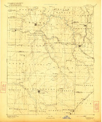
1886 Map of Greenfield
USGS Topo · Published 1921About this map
Greenfield and Mount Vernon serve as the primary hubs in this late 19th-century study of southwest Missouri. The landscape is defined by the convergence of agricultural prairies like Rock Prairie and a dense network of watercourses, including Turnback Creek, Limestone Creek, and the Spring River. This era was characterized by the rapid expansion of rail infrastructure, with the Kansas City Clinton and Springfield Railroad and the Kansas City Fort Scott and Gulf Railroad carving paths through the rolling terrain to connect small trade centers such as Everton and Ash Grove.
Find a feature on this map
78 named features on this map. Tap any name to fly to it.
Don’t see what you’re looking for? This feature index may not catch every label — zoom into the map to look around manually.
Map Details
Editions of this 1886 Greenfield Map
4 editions found
Other maps of this area

1884 · Springfield
USGS Topo · 1:125,000

1884 · Bolivar
USGS Topo · 1:125,000

1886 · Nevada
USGS Topo · 1:125,000

1886 · Stockton
USGS Topo · 1:125,000

1886 · Greenfield
USGS Topo · 1:125,000

1886 · Carthage
USGS Topo · 1:125,000

1886 · Springfield
USGS Topo · 1:125,000

1888 · Greenfield
USGS Topo · 1:125,000

1892 · Bolivar
USGS Topo · 1:125,000

1894 · Nevada
USGS Topo · 1:125,000