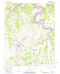
1956 Map of Greenfield
USGS Topo · Published 1982About this map
Greenfield serves as the focal point of this Dade County landscape, situated at a transition where the winding Sac River and its major tributary, Turnback Creek, meet the expanding waters of Stockton Lake. The map reveals a deeply etched terrain defined by landmarks like Shaw Bluff and Winkle Bluff, alongside the subterranean interest of Hoyle Cave. Small rural communities and family legacies are preserved through numerous local institutions, including Mount Olive Ch, Carr Chapel, and the Wetzel Cem. Transportation through the region was historically anchored by the Burlington Northern railroad, which cuts through the southern townships of Center and Washington. An interpretive look at the revisions shows the impact of the Stockton Lake reservoir, which flooded the low-lying river valleys, permanently altering the original paths of Sons Creek and the river banks near Fiddlers Ford.
Find a feature on this map
34 named features on this map. Tap any name to fly to it.
Don’t see what you’re looking for? This feature index may not catch every label — zoom into the map to look around manually.
Map Details
Editions of this 1956 Greenfield Map
3 editions found
Other maps of this area

1886 · Stockton
USGS Topo · 1:125,000

1886 · Greenfield
USGS Topo · 1:125,000

1888 · Greenfield
USGS Topo · 1:125,000

1954 · Springfield
USGS Topo · 1:250,000

1955 · Dadeville
USGS Topo · 1:24,000
1956 · Kings Point
USGS Topo · 1:24,000

1956 · Greenfield
USGS Topo · 1:24,000
1956 · Lockwood
USGS Topo · 1:24,000
1956 · Bona
USGS Topo · 1:24,000
1956 · South Greenfield
USGS Topo · 1:24,000