1886 Map of Greenfield
USGS Topo · Published 1950About this map
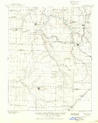
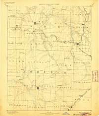
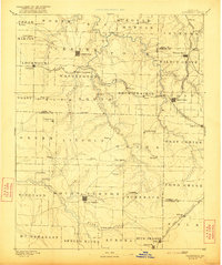
Greenfield and Mount Vernon anchor this 1884 reconnaissance survey of Southwest Missouri, reflecting a period of significant agricultural and rail expansion. The landscape is defined by the convergence of three major rail lines, including the Kansas City Clinton and Springfield Railroad and the Kansas City Fort Scott and Gulf Railroad, which spurred the growth of shipping points like Lockwood and Everton. Outside the larger town centers, the terrain is dotted with small family-named landmarks and rural settlements such as Sim's Point, Kings Point, and Yingst. Waterways like Turnback Creek and the Spring River provide the natural framework for these emerging townships. The map documents the early political boundaries where Dade, Lawrence, and Greene counties meet, illustrating the late nineteenth-century settlement patterns of the Ozark plateau.
Find a feature on this map
78 named features on this map. Tap any name to fly to it.
Don’t see what you’re looking for? This feature index may not catch every label — zoom into the map to look around manually.
Map Details
Editions of this 1886 Greenfield Map
4 editions found
Other maps of this area

1884 · Springfield
USGS Topo · 1:125,000

1884 · Bolivar
USGS Topo · 1:125,000

1886 · Nevada
USGS Topo · 1:125,000

1886 · Stockton
USGS Topo · 1:125,000

1886 · Greenfield
USGS Topo · 1:125,000

1886 · Carthage
USGS Topo · 1:125,000

1886 · Springfield
USGS Topo · 1:125,000

1888 · Greenfield
USGS Topo · 1:125,000

1892 · Bolivar
USGS Topo · 1:125,000

1894 · Nevada
USGS Topo · 1:125,000