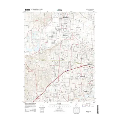
2013 Map of Greenhills
USGS Topo · Published 2013About this map
The Great Miami River flows along the western edge of this landscape, marking the transition from the rolling terrain near Bevis to the more developed corridors of Hamilton and Fairfield. This region is defined by its significant collection of memorial grounds and early burial sites, ranging from the large Crown Hill Memorial Park to smaller, localized spots like Schulniger Cem and Huston Cem. These cemeteries, along with Saint Marys Cem and the Jewish Cem, offer a rich field of study for those tracing family lineages in Butler and Hamilton Counties.
Find a feature on this map
61 named features on this map. Tap any name to fly to it.
Don’t see what you’re looking for? This feature index may not catch every label — zoom into the map to look around manually.
Map Details
Editions of this 2013 Greenhills Map
This is the sole edition of this map. No revisions or reprints were ever made.
Other maps of this area

1898 · East Cincinnati
USGS Topo · 1:62,500

1904 · Mason
USGS Topo · 1:62,500

1906 · Mason
USGS Topo · 1:62,500

1914 · East Cincinnati
USGS Topo · 1:62,500

1914 · West Cincinnati
USGS Topo · 1:62,500

1915 · Hamilton
USGS Topo · 1:62,500

1917 · Hamilton
USGS Topo · 1:62,500
1953 · Cincinnati East
USGS Topo · 1:24,000

1953 · Cincinnati West
USGS Topo · 1:24,000

1953 · Cincinnati
USGS Topo · 1:250,000