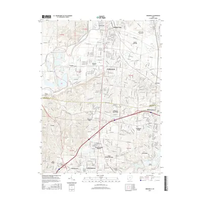
2016 Map of Greenhills
USGS Topo · Published 2016About this map
The Great Miami River anchors this suburban landscape where the southern reaches of Hamilton meet the expanding communities of Fairfield and Forest Park. This modern survey reveals a densely developed corridor crossing the Butler Co Hamilton Co line, illustrating the mid-century suburban evolution of residential tracts like Pleasant Run Farm and Indian Springs. For genealogists and local historians, the map serves as a vital record of several smaller burial grounds including Huston Cem, Schlunger Cem, and the Fairfield Trustees Cem, which remain as quiet landmarks amidst the contemporary road network.
Find a feature on this map
103 named features on this map. Tap any name to fly to it.
Don’t see what you’re looking for? This feature index may not catch every label — zoom into the map to look around manually.
Map Details
Editions of this 2016 Greenhills Map
This is the sole edition of this map. No revisions or reprints were ever made.
Other maps of this area

1898 · East Cincinnati
USGS Topo · 1:62,500

1904 · Mason
USGS Topo · 1:62,500

1906 · Mason
USGS Topo · 1:62,500

1914 · East Cincinnati
USGS Topo · 1:62,500

1914 · West Cincinnati
USGS Topo · 1:62,500

1915 · Hamilton
USGS Topo · 1:62,500

1917 · Hamilton
USGS Topo · 1:62,500
1953 · Cincinnati East
USGS Topo · 1:24,000

1953 · Cincinnati West
USGS Topo · 1:24,000

1953 · Cincinnati
USGS Topo · 1:250,000