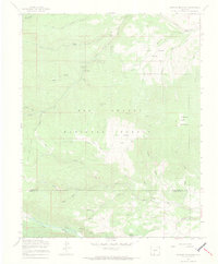
1967 Map of Greenie Mountain
USGS Topo · Published 1970About this map
Camp Val Verde and Lost Cabin Ranch sit within the high-elevation landscape of the Rio Grande National Forest during the late 1960s. The map illustrates a region defined by its reliance on seasonal access and specialized encampments, such as the Phillips University Camp near the Alamosa River. A network of primitive transportation routes, including Jeep Trails, Pack Trails, and a dedicated Stock Driveway, indicates a working landscape of ranching and forestry rather than permanent urban settlement.
Find a feature on this map
48 named features on this map. Tap any name to fly to it.
Don’t see what you’re looking for? This feature index may not catch every label — zoom into the map to look around manually.
Map Details
Editions of this 1967 Greenie Mountain Map
4 editions found
Other maps of this area

1915 · Del Norte
USGS Topo · 1:125,000

1917 · Del Norte
USGS Topo · 1:125,000

1922 · Conejos
USGS Topo · 1:125,000

1945 · Durango
USGS Topo · 1:250,000

1953 · Durango
USGS Topo · 1:250,000

1954 · Durango
USGS Topo · 1:250,000

1961 · Durango
USGS Topo · 1:250,000

1963 · Durango
USGS Topo · 1:250,000

1964 · Monte Vista
USGS Topo · 1:24,000

1966 · Durango
USGS Topo · 1:250,000