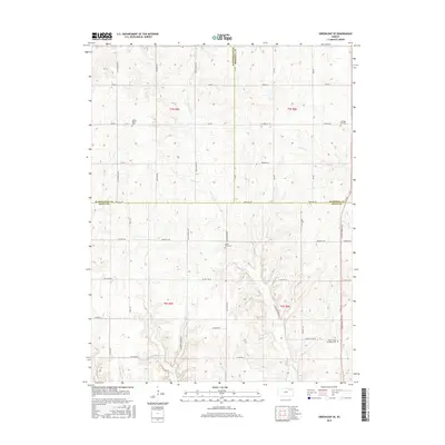
2015 Map of Greenleaf SE
USGS Topo · Published 2015About this map
The rolling agricultural landscape of north-central Kansas is defined by the intersection of three counties, where the borders of Washington, Marshall, and Riley converge. This 2015 record shows a countryside structured by an orderly grid of section roads like All American Rd and Parallel Rd, which traverse the high ground between numerous local waterways. The drainage pattern is complex, with Sulphur Cr and Swede Cr carving through the northern sections while N Otter Cr and its tributaries dominate the southern half of the quadrangle.
Find a feature on this map
47 named features on this map. Tap any name to fly to it.
Don’t see what you’re looking for? This feature index may not catch every label — zoom into the map to look around manually.
Map Details
Editions of this 2015 Greenleaf SE Map
This is the sole edition of this map. No revisions or reprints were ever made.
Other maps of this area

1886 · Junction City
USGS Topo · 1:125,000

1889 · Marysville
USGS Topo · 1:125,000

1889 · Junction City
USGS Topo · 1:125,000

1894 · Junction City
USGS Topo · 1:125,000

1894 · Marysville
USGS Topo · 1:125,000

1955 · Manhattan
USGS Topo · 1:250,000

1956 · Manhattan
USGS Topo · 1:250,000

1957 · Manhattan
USGS Topo · 1:250,000
1963 · Lasita
USGS Topo · 1:24,000
1964 · Randolph
USGS Topo · 1:24,000