
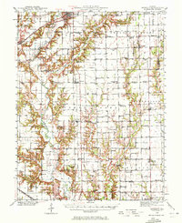
1940 Map of Greenup
USGS Topo · Published 1958About this map
The Embarrass River carves a deep, winding valley through the center of this landscape, flanked by a network of drainage creeks including Cottonwood Creek, Muddy Creek, and Crooked Creek. This 1940 survey documents a densely settled rural interior at the border of Cumberland and Jasper Counties, characterized by a remarkably high concentration of neighborhood institutions. One-room schoolhouses like Weatherholt Sch, Hamilton Sch, and Little Brown Sch are spaced frequently across the township grids, alongside numerous local places of worship such as Mt Zion Ch and the Universalist Ch.
Find a feature on this map
85 named features on this map. Tap any name to fly to it.
Don’t see what you’re looking for? This feature index may not catch every label — zoom into the map to look around manually.
Map Details
Editions of this 1940 Greenup Map
2 editions found
Other maps of this area

1910 · Hardinville
USGS Topo · 1:62,500

1933 · Toledo
USGS Topo · 1:62,500

1934 · Mattoon
USGS Topo · 1:62,500

1936 · Casey
USGS Topo · 1:48,000

1937 · Mattoon
USGS Topo · 1:62,500

1938 · Toledo
USGS Topo · 1:62,500

1941 · Newton
USGS Topo · 1:62,500

1942 · Casey
USGS Topo · 1:62,500

1943 · Greenup
USGS Topo · 1:62,500

1943 · Casey
USGS Topo · 1:62,500