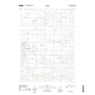
2019 Map of Greenville East
USGS Topo · Published 2019About this map
Greenville serves as the primary hub of this Montcalm County landscape, where the town's street grid meets the winding waters of Edwards Creek. The surrounding area is a transition from residential developments like Eureka Place to an expansive rural network of family farms and wetland basins. Water defines the terrain, from the sprawling Churchill Lake to the scattered glacial depressions of Mud Lake, Fish Lake, and Race Lake.
Find a feature on this map
99 named features on this map. Tap any name to fly to it.
Don’t see what you’re looking for? This feature index may not catch every label — zoom into the map to look around manually.
Map Details
Editions of this 2019 Greenville East Map
This is the sole edition of this map. No revisions or reprints were ever made.
Other maps of this area

1954 · Midland
USGS Topo · 1:250,000

1958 · Midland
USGS Topo · 1:250,000

1959 · Midland
USGS Topo · 1:250,000

1959 · Howard City
USGS Topo · 1:62,500

1964 · Langston
USGS Topo · 1:24,000

1964 · Stanton
USGS Topo · 1:24,000

1966 · Midland
USGS Topo · 1:250,000

1972 · Greenville West
USGS Topo · 1:24,000
1972 · Belding
USGS Topo · 1:24,000
1972 · Greenville East
USGS Topo · 1:24,000