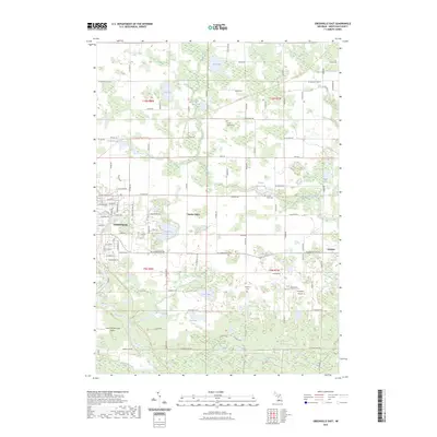
2023 Map of Greenville East
USGS Topo · Published 2023About this map
Greenville serves as the primary hub in this portion of Montcalm County, situated along the banks of the Flat River. The landscape is defined by a dense concentration of small glacial lakes and wetlands, including Loon Lake, Thorland Lake, and Sanderson Lake, which are linked by winding waterways like Dickerson Creek. This area shows a transition from the urban grid of the city to a rural patchwork of section lines and recreational corridors, most notably the Fred Meijer Heartland Trl which traverses the northern half of the quadrangle. Local history and genealogy interests are well-represented by several burial grounds, including the South Sidney Cem and the small Potter's Field Cem located near the County Farm Pond. Aviation is central to the local infrastructure, with both the Greenville Municipal Airport and Fairplains Airpark serving the region.
Find a feature on this map
98 named features on this map. Tap any name to fly to it.
Don’t see what you’re looking for? This feature index may not catch every label — zoom into the map to look around manually.
Map Details
Editions of this 2023 Greenville East Map
This is the sole edition of this map. No revisions or reprints were ever made.
Other maps of this area

1954 · Midland
USGS Topo · 1:250,000

1958 · Midland
USGS Topo · 1:250,000

1959 · Midland
USGS Topo · 1:250,000

1959 · Howard City
USGS Topo · 1:62,500

1964 · Langston
USGS Topo · 1:24,000

1964 · Stanton
USGS Topo · 1:24,000

1966 · Midland
USGS Topo · 1:250,000

1972 · Greenville West
USGS Topo · 1:24,000
1972 · Belding
USGS Topo · 1:24,000
1972 · Greenville East
USGS Topo · 1:24,000