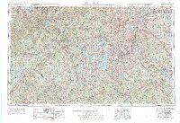
1954 Map of Greenville
USGS Topo · Published 1976About this map
The Blue Ridge mountains dominate the northern landscape of this mid-century survey, where the peaks of Brasstown Bald and Whiteside Mountain overlook the Piedmont. The map captures a critical period of infrastructure development in the Upstate and Northeast Georgia, specifically showing the emergence of major reservoirs like Hartwell Lake and Lake Sidney Lanier. These massive water bodies redefined the geography of the Savannah River and Chattooga River basins, altering local transport and recreation patterns just as Interstate 85 began to reshape the region's corridor.
Find a feature on this map
97 named features on this map. Tap any name to fly to it.
Don’t see what you’re looking for? This feature index may not catch every label — zoom into the map to look around manually.
Map Details
Editions of this 1954 Greenville Map
3 editions found

Other maps of this area

1886 · Dahlonega
USGS Topo · 1:125,000

1886 · Walhalla
USGS Topo · 1:125,000

1888 · Ellijay
USGS Topo · 1:125,000

1888 · Pickens
USGS Topo · 1:125,000

1888 · Atlanta
USGS Topo · 1:125,000

1890 · Suwanee
USGS Topo · 1:125,000

1890 · Atlanta
USGS Topo · 1:125,000

1891 · Cowee
USGS Topo · 1:125,000

1891 · Gainesville
USGS Topo · 1:125,000

1891 · Carnesville
USGS Topo · 1:125,000