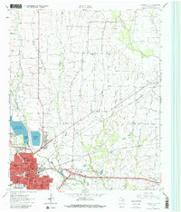
1963 Map of Greenville NE
USGS Topo · Published 1981About this map
Greenville serves as the industrial and transportation hub of this Hunt County landscape, dominated by a dense network of railway lines in the early 1960s. The St Louis Southwestern and Missouri Kansas and Texas Railroad converge near the city center, while an Old Railroad Grade and abandoned tracks trace the changing economic priorities of the era. North of the city, the Cowleech Fork Sabine River and South Sulphur River carve through the terrain, flanked by smaller communities like Neylandville and Peniel.
Find a feature on this map
46 named features on this map. Tap any name to fly to it.
Don’t see what you’re looking for? This feature index may not catch every label — zoom into the map to look around manually.
Map Details
Editions of this 1963 Greenville NE Map
Other maps of this area

1953 · Texarkana
USGS Topo · 1:250,000

1954 · Sherman
USGS Topo · 1:250,000

1956 · Texarkana
USGS Topo · 1:250,000

1958 · Sherman
USGS Topo · 1:250,000

1962 · Greenville NW
USGS Topo · 1:24,000

1962 · Greenville SW
USGS Topo · 1:24,000

1962 · Greenville SE
USGS Topo · 1:24,000

1962 · Lone Oak North
USGS Topo · 1:24,000

1963 · Greenville NE
USGS Topo · 1:24,000

1964 · Commerce South
USGS Topo · 1:24,000