
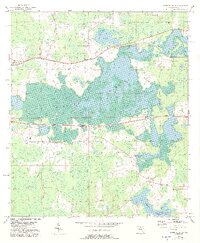
1954 Map of Greenville NE
USGS Topo · Published 1956About this map
Hixtown Swamp dominates the center of this North Florida landscape, a complex of wetlands and varying terrain where the Base Line survey marker cuts through the pine-dotted lowlands. The western edge of the sheet shows the edge of Greenville, where the Seaboard Air Line railroad tracks run eastward toward the small community of Chapel. This mid-century survey reveals a rural economy organized around these rail corridors and scattered local landmarks, such as the Concord Ch and Cross Road Sch. To the south, the terrain opens into significant water bodies including Indian Lake and Sampala Lake, while family and community history is preserved at Evergreen Cem and Oakland Cem. The mapping, compiled from 1951 aerial photography, provides a clear view of the drainage patterns of Sundown Creek and the undeveloped character of Madison County during this era.
Find a feature on this map
12 named features on this map. Tap any name to fly to it.
Don’t see what you’re looking for? This feature index may not catch every label — zoom into the map to look around manually.
Map Details
Editions of this 1954 Greenville NE Map
2 editions found
Other maps of this area

1954 · Greenville
USGS Topo · 1:24,000

1954 · Valdosta
USGS Topo · 1:250,000

1955 · Shady Grove
USGS Topo · 1:24,000

1955 · Greenville SE
USGS Topo · 1:24,000

1958 · Valdosta
USGS Topo · 1:250,000

1958 · Madison SW
USGS Topo · 1:24,000

1959 · Valdosta
USGS Topo · 1:250,000

1959 · Madison
USGS Topo · 1:24,000

1960 · Cherry Lake
USGS Topo · 1:24,000

1962 · Ashville
USGS Topo · 1:24,000