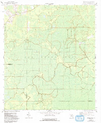
1958 Map of Madison SW
USGS Topo · Published 1993About this map
San Pedro Bay dominates this landscape, a vast wetlands area straddling the border between Madison and Taylor counties in the Florida Panhandle. The map reveals a remote territory largely defined by its drainage and natural features, such as the headwaters of the Fenholloway River. Human settlement is minimal, represented by the New Oakland Ch in the northwestern corner and a network of unmarked roads labeled only as Private. The presence of the Sinclair Lookout suggests the importance of timber management and fire surveillance within the dense bay vegetation during the mid-20th century. This survey, based on aerial photography from the early 1950s and planetable work in 1958, provides a clear record of the area's hydrology before later industrial or agricultural alterations occurred.
Find a feature on this map
7 named features on this map. Tap any name to fly to it.
Don’t see what you’re looking for? This feature index may not catch every label — zoom into the map to look around manually.
Map Details
Editions of this 1958 Madison SW Map
2 editions found
Other maps of this area

1954 · Day
USGS Topo · 1:24,000

1954 · Boyd
USGS Topo · 1:24,000

1954 · Day NW
USGS Topo · 1:24,000

1954 · Greenville NE
USGS Topo · 1:24,000

1954 · Valdosta
USGS Topo · 1:250,000

1955 · Greenville SE
USGS Topo · 1:24,000

1958 · Valdosta
USGS Topo · 1:250,000

1958 · Madison SW
USGS Topo · 1:24,000

1958 · Madison SE
USGS Topo · 1:24,000

1958 · Lee
USGS Topo · 1:24,000